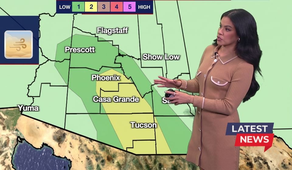

Residents across the Phoenix metropolitan area and much of central Arizona were urged to prepare for hazardous weather after forecasters upgraded the region’s weekend storm threat to a Category 2 risk. The higher threat level reflects an increased likelihood of severe thunderstorms capable of producing powerful wind gusts, blowing dust, torrential rainfall, dangerous lightning, and localized flooding as monsoon moisture continues to build across the state.
The upgraded forecast came as meteorologists warned that weather conditions would become increasingly unstable through Saturday evening and overnight, creating the potential for rapidly developing storms that could affect travel, outdoor activities, and public safety.
Why the Storm Threat Was Upgraded
Higher Risk of Severe Thunderstorms
According to forecasters, the arrival of deeper monsoon moisture combined with daytime heating and atmospheric instability prompted the upgrade to a Category 2 severe weather outlook. While scattered thunderstorms are common during Arizona’s monsoon season, the enhanced risk indicates a greater chance that some storms could become severe.
Meteorologists warned that the strongest storms could produce damaging straight-line winds, intense lightning, heavy rainfall, and widespread blowing dust. These hazards have the potential to create dangerous conditions within a short period, particularly during the late afternoon and evening hours.
Monsoon Moisture Driving the Weather Pattern
Arizona’s annual monsoon season typically brings a surge of moisture from the south, fueling afternoon and evening thunderstorms. In this event, forecasters noted that moisture levels had increased significantly, providing the ingredients needed for stronger storm development across the Valley and surrounding desert communities.
Dangerous Winds Expected to Be the Primary Hazard
Powerful Wind Gusts Could Cause Damage
The greatest concern associated with the storms is the potential for strong and damaging wind gusts. These winds can down trees, damage power lines, blow unsecured outdoor objects, and create hazardous driving conditions.
Even storms producing little rainfall can generate powerful outflow winds that spread rapidly away from thunderstorms. In the Arizona desert, these winds frequently lift large amounts of dust into the air, dramatically reducing visibility.
Blowing Dust Creates Life-Threatening Travel Conditions
One of the most significant dangers during Arizona’s monsoon season is blowing dust, commonly known as a haboob. Strong thunderstorm outflow winds can push massive walls of dust across highways and populated areas with little warning.
Forecasters issued dust alerts because visibility can quickly drop from clear conditions to nearly zero within minutes. Such events have been responsible for numerous traffic accidents across Arizona, especially on major highways where drivers may suddenly lose sight of the road ahead.
Heavy Rain Could Trigger Localized Flooding
Flash Flood Risk Increases in Low-Lying Areas
Although not every community is expected to receive significant rainfall, thunderstorms that do develop could produce intense downpours over a short period.
Because Arizona’s desert soil absorbs water slowly, heavy rainfall can quickly overwhelm washes, intersections, and drainage systems. Low-water crossings and flood-prone roads may become dangerous within minutes, even after relatively brief storms.
Urban Flooding Remains a Concern
Highly developed areas around Phoenix are particularly susceptible to localized flooding during intense monsoon storms. Streets, underpasses, parking lots, and neighborhoods with poor drainage may experience temporary flooding if storms stall over the same location.
Emergency officials routinely remind motorists never to drive through flooded roadways because water depth and roadway damage may not be visible.
Lightning Remains a Serious Threat
Outdoor Activities Could Become Dangerous
In addition to damaging winds and heavy rain, every thunderstorm carries the risk of dangerous cloud-to-ground lightning.
Residents planning outdoor recreation, sporting events, hiking, or travel were encouraged to closely monitor weather conditions and seek sturdy shelter immediately if thunderstorms approach.
Lightning remains one of the leading weather-related hazards during Arizona’s summer monsoon season.
Areas Most Likely to Be Affected
Phoenix Metro and Central Arizona
The upgraded outlook primarily impacts the Phoenix metropolitan area along with portions of central Arizona where atmospheric conditions favor stronger thunderstorm development.
While not every neighborhood will experience severe weather, meteorologists emphasized that isolated storms could become intense enough to produce damaging impacts wherever they form.
Safety Recommendations for Residents
Stay Weather Aware
Officials encouraged residents to monitor updated forecasts throughout the day because thunderstorm intensity and storm tracks can change rapidly.
People were advised to:
- Secure outdoor furniture and loose objects before storms arrive.
- Delay unnecessary travel if dust storms develop.
- Slow down and pull completely off the roadway if visibility drops due to blowing dust.
- Avoid driving through flooded streets or washes.
- Seek shelter indoors immediately when lightning is nearby.
- Keep mobile devices charged and enable emergency weather alerts.
These precautions can significantly reduce the risk of injury during rapidly changing weather conditions.
What Category Two Means
Elevated Potential for Severe Weather
A Category 2 severe weather outlook indicates an elevated risk for organized thunderstorms capable of producing hazardous weather compared with a lower-level outlook. While widespread severe weather is not guaranteed, the probability of damaging storms is high enough to warrant increased public awareness and preparedness.
Forecasters stressed that even isolated severe storms can cause significant impacts, particularly when accompanied by destructive wind gusts, blowing dust, heavy rainfall, and dangerous lightning.
Forecast Outlook
Storm Chances Continue Through the Weekend
Meteorologists indicated that the active monsoon pattern is expected to continue through the weekend, meaning additional rounds of thunderstorms remain possible after the initial wave of storms.
Residents were encouraged to remain alert for updated watches, warnings, and advisories, as individual storms may strengthen quickly and produce hazardous conditions with little advance notice. The combination of gusty winds, dust, heavy rain, and localized flooding means weather conditions can change rapidly across central Arizona during the active monsoon period.